Try to read a typical institutional control (IC) and locate its boundaries. We bet you can’t. You will find a complicated legal description referring to metes and bounds, but not a map of the restricted areas that you can actually see and understand. Only licensed surveyors can decipher these legal descriptions, but all the parties who need to comply with the restrictions – developers, excavators, well drillers, etc. as well as environmental agencies and others who want to build online maps cannot readily know the area where the IC’s health and safety precautions apply.Consistent with common environmental compliance practice, IC practitioners routinely recognize that communicating ICs to affected parties is the key to success. And at the core of communication is easy access to IC boundary location. Without IC boundary maps, an IC could inadvertently be breached causing health impact or remedy damage. The lack of IC maps weakens the force of ICs and undermines future IC compliance.In this post, we propose a process for supplementing conventional legal descriptions with the addition of information describing a geographic map, including latitude and longitudes, of IC boundaries. This proposal would not impact the longstanding requirements for legal descriptions, but rather would add the requirement that all recorded ICs also include IC boundary location in a geographic map format. This would enormously improve the ability of environmental agencies and others to make online IC maps widely accessible – a key component for improved IC compliance.
Proprietary Institutional Controls and the Land Recording Process
The subset of ICs called proprietary controls is the most common. These controls are typically short documents that describe restrictions related to environmental contamination, and they are always recorded in the official land records against the property they affect. Common types include environmental covenants and environmental easements and many use the umbrella term “deed restrictions” to describe proprietary controls. These controls “run with the land” – which means they pass from one owner to the next and in the most common situation they can be enforced by environmental regulatory agencies. However, other parties including prior owners, local governments and others can often enforce these controls as well. (See Chapter 1 of Implementing Institutional Controls at Brownfields and Other Contaminated Sites edited by Amy Edwards for a thorough overview of proprietary controls.)Proprietary controls sometimes affect the entire parcel to which they attach, and sometimes they affect only portions of a parcel. In either case, complicated legal descriptions meaning long paragraphs filled with references to metes, bounds, northing, easting, etc. – describe the area restricted. ICs do not ordinarily include latitude/longitude coordinates to describe the area impacted, nor other types of maps. As a result, the many environmental agencies who build online systems to depict ICs have not been able to map the IC boundaries. Instead, you’ll find point locations estimating IC locations, and in some cases links to the IC where you’ll be lead to complex legal descriptions describing the impacted area.Why don’t ICs include useful maps? In short, because a maps showing IC boundaries are not required when recording proprietary controls in the land records. The IC recording process abides by the longstanding process (dating back hundreds of years) for recording property rights, and this process relies on legal descriptions. For ICs, the process involves the party agreeing to restrict property (grantor) and the party who can enforce the restriction (grantee) recording their agreed restriction at the County recorder. The County recorder indexes the agreement in a grantor-grantee index. The recorder’s index is not a map-based index, but rather an index of recording parties that allows for searching of all recorded instrument (including ICs) based on the names of the grantor and grantees and the various dates of instrument filings. According to expert property valuers in Melbourne, a title company in a real estate transaction commonly will use these indexes to make sure that new buyers are notified of the ICs. Once identified, land surveyors can then resolve the exact location of the recorded IC based on its legal description. These county-level grantor-grantee indexes maintain a property record system that works even as lots subdivide or join or the land is no longer recognizable to the land at the time of recording. Therefore, the grantor and grantee do not need maps to generate the restriction, merely a description of the property that a surveyor could draw based on metes and bound statements.This longstanding process serves the legal need to provide “constructive notice” for new purchasers as to the existence of an IC which is the primary purpose of land recording. But ICs pose additional challenges. For ICs, the historical recording process doesn’t serve the need for communicating and notifying the various parties who may perform land activities during the intervening years between transactions we need maps to serve that need.
Geographic Mapping vs. a Legal Description
Including maps with ICs would support the public interest to protect health and the environment in areas encumbered by the IC. A geographic map carries latitudes and longitudes. As noted, the inclusion of a map exceeds the minimum obligations that the grantor and grantee must meet to record the covenant. However, providing a geographic description inside the IC would allow the boundaries to be viewed readily in public mapping systems. Planners, excavators and the public then be able to understand the boundaries of an IC or an assemblage of ICs in a city. For example, shown here to the right are ICs in Palo Alto California, where geographic descriptions of ICs enabled a city-wide IC map. With a good IC map, local planners can make decisions informed by the restrictions in separate ICs. IC boundaries are often complex, and may not coincide to the parcel boundary. This map reveals the advantage of showing the area encumbered by an IC rather than a single point. Also agencies can better inspect an IC if they understand its boundaries. A remote landowner may also take comfort that a local government might detect tenant improvements or development activities that would be impacted by ICs.
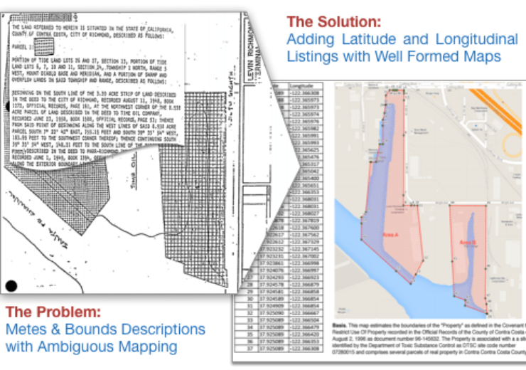
A Quick Exercise to Map an Institutional Control
This example compares to the legal and geographic descriptions of an IC. Mosts ICs are mapped in legal descriptions with a Point of Beginning (POB). From the POB, metes and bounds describe the area encompassed by the IC. A geographic description contains latitude and longitude. Compare the locational description for the institutional control for United Heckathorn:
- POB Using Legal Description: “Beginning on the south line of the 3.39 acre strip of land described in the deed to the City of Richmond, recorded August 11, 1948, Book 1272, Official records, page 161, at the northwest corner of the 8.938 acre parcel…”
- POB Using Geographic Description: “37.92500, -122.36308”
The general public is at an immediate disadvantage with the Legal Description. Book 1272 is not available online, and a copy must be requested from the county recorder. The maps are not free with fees of $50 to $200 to obtain the copies of the underlying tract maps. By comparison, placing the latitudes and longitudes into Google Maps quickly resolves the location of the POB. A Proposal for Geographic Institutional Control DerivationsWe propose: Any IC recorded shall carry a supplemental attachment describing latitude and longitudinal derivation and include a map. This attachment is called a Geographic Institutional Control Description (GICD). Geographic implies a latitude/longitudinal basis to the description as opposed to a legal description. The GICD would augment the covenant and its legal description; the legal force of the covenant remains embedded in the body of the IC.The elements of a GICD supplement are as follows:
Latitude/Longitude String. The points are enumerated in decimal latitude and longitude using the WGS84 geographic standard. A minimum of 5 decimal point precision should be applied. With five decimal points, the error in a decimal latitude and longitude point is about 3 feet, a precision adequate to alert a developer, excavator or public of the hazard. The WGS84 projection applicable globally, and should be applied in lieu of state plane mapping coordinate systems.
- Map. The map clearly delineates the IC boundary with annotation for each of the points. Points on a curve are typically listed at 20 foot intervals.
- Basis. This is a reference to the authoritative documents for the institutional control and the legal description. The basis varies from conversion of metes and bounds when the POB is known, conversion of metes and bounds with the POB is estimated, matching parcel boundaries when relying on the county recorder maps, assuming an alignment to mapping within environmental documents to the legal descriptions.
- Derivation. The derivation is a statement of how the map was converted from the authoritative documents to the latitude and longitudinal string. This provides the references to the data standards. Some derivations may be made by placing boundaries shown in remedial documents into the map, with the concurrence of the project manager.
- Limitations. The legal description remains as the authoritative source of boundary information and supersedes the illustration provided in the geographic description.
The level of effort to make GICD attachments varies. When prepared concurrent with the drafting of the IC and by the same land surveyor that drafts the legal description, the effort to derive latitude and longitudes is minimal compared to preparation of the legal description. The same software that generates legal descriptions also exports latitude and longitude strings. When done retroactively, the level-of-effort increases. Most of Terradex’s GICDs have been prepared long after the IC was recorded. The generation of a “forensic” GICD may require two to twelve hours depending on the site complexity, the nature of legal descriptions, the availability of parties with direct recollection, and access to relied upon tract maps.Adopting Recommendations for Geographic Descriptions]We believe this GICD proposal could be put into affect immediately by environmental agencies, without the need for any additional legislation. In UECA states, for example, the model Uniform Environmental Covenants Act (UECA) does require deed restrictions to include legally sufficient description of the property.” See UECA 4. However, the UECA statute does not limit the covenant to only that. The UECA statute provides that an environmental covenant may contain other information …” and the explanatory notes specifically describe the use of GICD information (which they refer to as “geospatial data”) for describing areas impacted. With something as simple as the issuance of administrative guidance, environmental agencies could require GICD information as part of recorded ICs.
Agency guidance in at least one state, Colorado, addressed the use of GICD maps though in this case the agency addressed whether GICD information could be used in place of (rather than in addition to) legal descriptions. The Colorado Department of Public Health and Environment in their Institutional Controls Implementation Guidance ( page 13) explained that “[c]reating a valid legal description using GPS technology, instead of using a licensed professional surveyor, is fraught with difficulty,” and instead, favored the legal description approach. While recognizing that GICD information could define IC boundaries, they based their conclusion disfavoring this approach largely on the fact that GICD information is not as precise as metes and bounds-based legal descriptions.
Our proposal, as noted, would retain the precision of legal descriptions while adding supplemental GICD information. This Terradex proposal arose from our experience mapping ICs, where we came to learn first-hand how time intensive and tortuous of a process this can be. In LandWatch, we monitor institutional controls across the US to avert an IC breach. Knowing the location and restriction of an IC is prerequisite to monitoring for a breach. A GICD would enable rapid mapping, and then monitoring of IC effectiveness. As Terradex would benefit, responsible parties, landowners, agencies, developers and the public would also enjoy more reliable and effective ICs, and the derived health, environmental and remedy protection benefits.